The IDRISI GIS Analysis system offers a wide range of fundamental analytical tools for GIS analysis, primarily oriented to raster data. Special features of the GIS Analysis tool set include a suite of multi-criteria and multi-objective decision procedures and a broad range of tools for statistical, change and surface analysis. Special graphical modeling environments are also provided for dynamic modeling and decision support. The GIS Analysis tool set also provides a scripting environment and an extremely flexible application programming interface (API) that allows the ability to control TerrSet using languages such as C++, Delphi and Python.
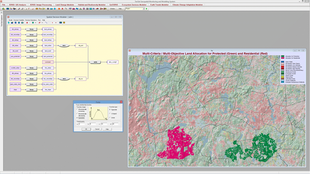
The Spatial Decision Modeler in TerrSet is a graphical modeling tool for multi-criteria and multi-objective decision support. This modeler incorporates tools for use of fuzzy sets to convert variables, the Analytical Hierarchy process to derive factor weights, and Ordered Weighted Averaging for multi-criteria evaluation. The tool also contains features for multi-objective land allocation that allows one to set land allocation targets based on either area or cost. There is also a facility to control contiguity and compactness in the land allocation process.
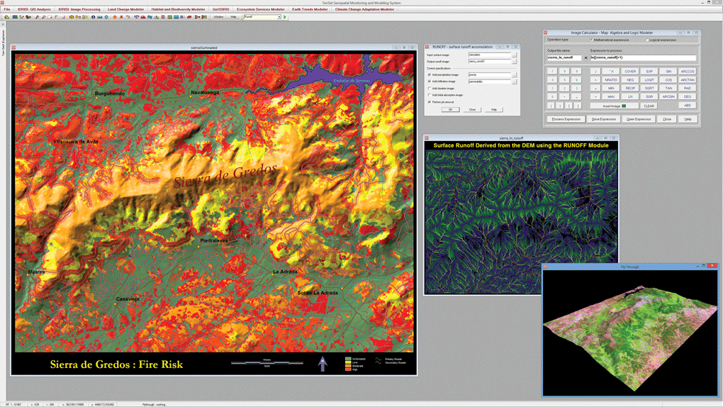
The foundation for TerrSet is the IDRISI GIS suite of analytical tools. This figure illustrates some of the many GIS analysis tools provided. These include a risk mapping based on a multi-criteria evaluation, a modeling of surface runoff incorporating information on precipitation and soil infiltration and the use of the the Image Calculator for basic map algebra tasks. The bottom right shows a view of the FlyThrough interactive 3-D flight viewer.
IDRISI GIS Analysis Key Features
Database Query
- The ability to query raster and vector map layers and report basic statistics as well as profiles over space and time, histograms, and tabulations of area and perimeter.
- For vector databases, an integrated relational database management tool used to enter and edit attribute data employing full SQL capabilities.
Derivative Mapping
- A full suite of mathematical and relational modeling tools for deriving new data layers as a function of existing layers.
- Models can be entered as equations with map layers as variables or through the use of a graphical modeling environment.
Distance and Context
- A rich set of context operations, including Euclidian and cost distance procedures, for the aggregation and disaggregation of directional forces and frictions, a least-cost path procedure, and spatial allocation routines.
- The ability to analyze patterns and textures, including the analysis of local context through filtering and aggregation of contiguous groups.
Spatial Statistics
- An entire suite of tools aimed at the description of spatial characteristics including geostatistics and interpolation.
- Tools include point distribution measures, simple and multiple image regression, logistical and multinomial logistical regression, autocorrelation procedures, pattern and texture measures, polynomial trend surface analysis and spatial sampling, and random generation procedures for support of Monte Carlo simulation.
Decision Support and Uncertainty Management
- A graphical modeling environment for multi-criteria and multi-objective decision support that includes tools and procedures for suitability mapping and land allocation.
- A land allocation procedure that takes into account contiguity and compactness.
- A consensus-seeking procedure for weighting criteria, fuzzy standardization, and an extensive set of criteria aggregation procedures based on Weighted Linear Combination and Ordered Weighted Averaging.
- Error propagation tools through Monte Carlo Simulation, the evaluation of decision risk as a result of propagated error, calculation and aggregation of Fuzzy Sets, and the aggregation of indirect evidence to support a weight-of-evidence conclusion using both Bayesian and Dempster-Shafer approaches.
- A soft reclassification procedure to map the probability of a location being above or below a threshold (such as sea level rise), as well as an implementation of spatial prior probabilities for Maximum Likelihood classification.
Surface Analysis
- Tools to derive patterns, trends, and topological features such as slope gradient, aspect, illumination (hillshading), and curvature.
- Interpolation procedures include inverse distance weighting, triangulated irregular network (TIN) modeling, Thiessen polygons, trend surface mapping and geostatistics.
- The ability to delineate watersheds and viewsheds, determine surface runoff and flow patterns, evaluate sedimentation and model soil erosion.
- Traditional distance and buffer analysis tools include cost distance and pathway analyses. Surface analysis modeling tools are provided for random image generation, image sampling, and image filtering.
Change and Time Series Analysis
- Tools to identify and quantify change across multiple images including image differencing, image ratioing, regression differencing, change vector analysis, and qualitative data analysis.
- A suite of tools for predictive land cover change modeling that includes Markov Chain Analysis, Cellular Automata, logistical regression and multinomial logistical regression, GEOMOD, and Artificial Neural Networks.
Model Deployment Tools
- Image Calculator, an interactive mathematical modeling tool that provides a simple calculator-like interface for constructing algebraic and logical formulas with map layers as variables.
- Macro Modeler, a graphical modeling environment that exposes all of the IDRISI GIS Analysis tools as objects that can be linked with map layers in an algorithmic chain.
- For the most demanding of algorithmic modeling applications, or for the development of stand-alone tools as add-ons to TerrSet, a scripting language such as Python or a full programming language such as C++ or Delphi can be deployed through the industry-standard COM object model interface.